AirMap Geo-awareness Technologies Power skyguide’s U-space Applications
![]()
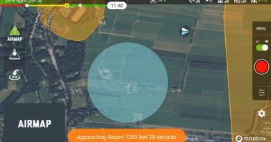
Santa Monica, CA—AirMap, the leading digital airspace and automation company serving the drone economy, and skyguide, the Swiss ANSP, are providing UAS operators in Switzerland with official aeronautical information via skyguide’s new geo-awareness applications. These web and mobile applications provide UAS operators with information and guidance that promote safe UAS operations in a common unique digital format.The AirMap platform makes it easy for skyguide app users to view up-to-date contextual airspace information, including active schedules for specific airspace.
Airspace restrictions are not static: they can change according to the day, time, or season. But many airspace data sources are not dynamic enough to denote active and inactive temporal restrictions and supply operators with schedule information. As a result, other geo-awareness applications may wrongly label scheduled airspace restrictions as indefinite. This results in an inaccurate operating picture that limits UAS operators’ access to the airspace.
The AirMap platform converts authoritative airspace data into a 4D digital twin of the airspace. Because skyguide’s U-space applications are powered by the AirMap platform, users can see schedules affiliated with special use airspace, filter airspace according to date and time, and plan their missions accordingly.
“UAS operators can ensure that their flights are safe and compliant by downloading and utilizing skyguide’s U-space applications,” said Robert Fraefel, U-space project lead at skyguide. “The AirMap platform ensures that operators receive up-to-date contextual airspace information from Swiss authorities.”
“AirMap invests in data innovation in order to unlock airspace for safe UAS operations around the globe,” said Boris Lacroix, AirMap’s Senior Vice President of Product Management. “Skyguide and FOCA have again demonstrated global leadership in drone enablement by making 4D contextual airspace intelligence available to application users nationwide.”
For more information about skyguide’s U-space apps, visit www.swissuspace.ch.
Learn more about AirMap’s geo-awareness solutions at airmap.com/authorities.
About skyguide
Skyguide provides air navigation services for Switzerland and certain adjacent parts of neighbouring countries. With its 1500 employees at 14 locations in Switzerland, the company guides some 1.3 million civil and military flights a year safely and efficiently through Europe’s most complex airspace.
Skyguide is well integrated into the international air navigation services community and, with its innovative and customer-minded solutions, helps enhance Switzerland’s appeal as a place to live, work and do business. The company is majority-owned by the Swiss Confederation, and is headquartered in Geneva.
About AirMap
AirMap is the leading digital airspace and automation company serving the drone economy. Airspace authorities and enterprises rely on the AirMap platform to safely operate drones in low altitude airspace and deliver critical business insights. AirMap offers best-in-class mission planning, flight and capture, and dataflow automation solutions to enterprises and third-party solution providers, who can connect their applications to AirMap’s open developer platform. AirMap’s UTM and U-space products are deployed in the Czech Republic, Japan, Singapore, Switzerland, the United States, and available in over 30 countries. The company serves a global community of over 250,000 operators and 2,700 registered developers. AirMap is committed to advancing Urban Air Mobility (UAM) through ongoing standards development work, global research initiatives, and industry collaboration. Learn more at www.airmap.com.


